The Ross and Monmouth
Railway
|
This railway had a fairly
self-explanatory title. Its aim in life was to link the town
of Ross, with its Hereford, Ross and Gloucester Railway, with
the town of Monmouth and its Coleford, Monmouth, Usk and Pontypool
Railway. This helpful little railway therefore had (it thought)
the opportunity to become a major north-south route while serving
lots of local communities and so enthusiastically rushed off
to obtain its Act of Parliament in 1865. This allowed it to raise
most of its planned budget before an economic collapse brought
on by the contractor on an adjacent railway in 1866 killed all
prospects of finding people with large sums of money.
This caused some problems
for its grand schemes, which would ultimately result in the map
seen at left. Small railways can be surprisingly bold, however,
and the Ross and Monmouth decided to push for it. Working south
from Ross, it completed both its tunnels, all three planned intermediate
stations, two of the three proposed river crossings and 12 of
its 13 miles before funding ran out in 1873, leaving it stuck
outside the May Hill pub at Monmouth wondering what to do next.
Its solution was probably the best possible option - it built
a temporary southern terminus (named after the pub) and inaugrated
services between Ross and Monmouth. The following year it crossed
the river, joined the line from Pontypool at Monmouth Troy, and
settled down to make money. |
The three intermediate stations
were called Kerne Bridge (which also served Goodrich and its
castle), Lydbrook Junction (about a mile from Lydbrook) and Symonds
Yat (perhaps the most perfectly situated station in the country,
sat at the bottom of a deep, rocky, wooded valley on the river
bank miles from anywhere). 1875 saw the Severn and Wye Railway
open their line from Serridge Junction, sat happily a mile from
anywhere in the middle of the Forest of Dean, to Lydbrook; it
terminated at Lydbrook Junction, giving the stop (theoretically)
four platforms (the fourth - the Severn and Wye's spare platform
- was actually probably never used very much) and therefore making
it the largest station on Monmouth's rail network. It also meant
that the Ross and Monmouth line was the only one of the four
railways from Monmouth to have an intermediate junction with
another railway - although the Wye Valley line did arrange to
have its own branch line.
The Ross and Monmouth was
arguably the most successful of Monmouth's branch lines, lasting
with a separate company until a merger with the Great Western
was forced by the Government in 1922. It developed some additional
traffic with various private sidings on the lower sections of
the line, while Walford Halt opened between Ross and Kerne Bridge
in 1931. Nationalisation in 1948 had little effect, although
a halt was opened at Hadnock in 1951 in an attempt to boost traffic
in an area where there wasn't enough to justify building a decent
platform. Kerne Bridge had lost its loop in the early 20th Century
and now Symonds Yat lost its too. The line was always worked
by steam locomotives; railway celebrity came towards the end
with locomotive No. 1401, as seen in the 1953 film The Titfield
Thunderbolt, working a few trains. It was not enough to
save the line; closure came at the beginning of 1959, with the
last regular trains on the 3rd of January, a final special on
the 4th and death on the 5th. The Wye Valley line provided freight
services to Monmouth's two stations while the Ross and Monmouth
was closed south of Lydbrook; the line north of Lydbrook to Ross
was retained for an Edison and Swann wireworks built in the triangle
between the lines at Lydbrook Junction. The section between Monmouth
May Hill and Monmouth Troy was shut in 1963, with Troy going
at the beginning of the following year. Five months later the
Hereford, Ross and Gloucester was closed, with Ross to Gloucester
being retained for that wireworks at Lydbrook; tiring of paying
the entire maintenance bill for a singularly expensive 15 miles
of railway, the wireworks shut in 1965 and the remains of the
line closed.
The pictures below - all taken
on the 3rd of January 2010 - give some idea of this route, reopening
possibilities and issues and what survives of a rather splendid,
if slow, bit of railway.
|
Monmouth Troy

|
Our journey to Ross begins
from Platform 2 at Monmouth Troy, looking towards the station's
east throat where the Ross and Monmouth line ran straight ahead
before curving north and crossing the river to head for Monmouth
May Hill, while the Wye Valley line branched off and curved gently
away on its own viaduct to Wyesham before curving south and departing
for Chepstow. Behind the camera trains ran through Monmouth Tunnel
to Pontypool; for the first 40 years of the Ross line's career
it was worked as a through line from Ross to Pontypool, but the
amalgamation of the Ross and Monmouth into the Great Western
saw the through route split, with passengers changing at Troy.
Monmouth's principal station
was not quite the typical country junction - it had no bay platforms
for branch trains, for example - and generally had the appearance
of a minor through station. However, after the First World War
the three lines which congregated on this spot all treated it
as a terminus and for the second half of 1954 - its peak year
- its 19 daily terminating passenger and 3 goods trains must
have created fairly perpetual bustle - particularly by rural
junction standards. Kitted out with a large main building, small
refreshment room and spacious goods yard, it was arguably the
best station that Monmouth could have had - apart from its location,
which was poor, and the quality of through services to places
away from the branch lines, which (apart from Wye Valley services
terminating at Severn Tunnel Junction, thereby sort of connecting
with the mainline from South Wales to London) were non-existent.
Troy station provided the
Ross and Monmouth Railway with a good southern terminus for 85
years, until all trains from Ross ceased in 1959. Its goods yard
has gone, buried under new housing, but a gas station in the
old station throat has saved the station site from redevelopment
for now. It has recently been cleared of overgrowth, revealing
its size (quite large compared to stations on surrounding lines)
once more.
None of its four lines retain
completely intact trackbeds; the most intact and therefore most
likely to be resurrected is that from Chepstow along the Wye
Valley. Those less familiar with the terrain should note as a
basis that the Wye Valley Railway (Chepstow to Monmouth) is traditionally
distinct from and should not be confused with all other railways
along the long path of the Wye - unless referring to the 1985
company set up to recommence services between Chepstow, Monmouth,
Ross, Hereford and Gloucester. |
|
Monmouth May Hill
|
Monmouth May Hill was the
temporary terminus of the Ross and Monmouth Railway and so for
six months it represented Monmouth's rail outlet to the north.
It was never given any freight facilities to speak of, although
it did have a couple of private sidings - principally Troy handled
all the messy stuff, while May Hill only handled passengers.
As May Hill was only served
by trains to and from Ross for much of its life it did less business
than Troy, despite its far more convenient location for the town
centre. This convenient location meant that trains likely to
carry schoolchildren ran through to May Hill occasionally from
the Pontypool line (although since Wye Valley trains would have
to turn at Troy to access May Hill and operators down the years
never wanted to suggest that this was possible, Wye Valley schoolchildren
just had to get off at Troy and walk). Other trains terminated
at Troy and so it was that station which got most bookings to
and from the Chepstow and Pontypool lines.
When closure came up May Hill
was offered the rather unlikely prospect of promotion for a very
brief period. The big idea from the locals was to concentrate
trains on May Hill, perhaps ultimately axing the river crossings
and re-instating the long gone third side of the triangle between
Wyesham Halt and Monmouth May Hill. It was never going to happen;
BR wasn't the sort of organisation that could get its head around
such developments (the goods yard would need moving at enormous
expense and May Hill would need resignalling; if trains were
to continue using Troy then BR would just be puzzled as to why
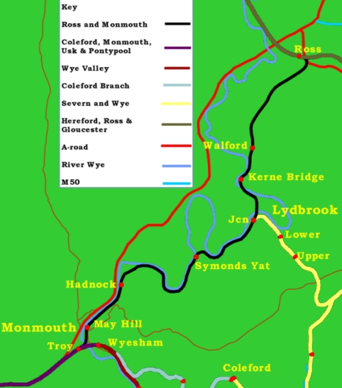
passengers couldn't change there or walk into Monmouth). Instead
the timber buildings were razed to the ground and sports fields
cover the site. This is the view from the access road; the station
was located in front of where the large brick building in the
centre now stands.
Proposals to re-open the line
in 1985 thought that avoiding Troy would be a good idea; there
was no need to worry about the goods yard by then and presumably
the site was still available. Nowadays a station on the exact
site of May Hill is essentially out of the question. Room remains
on the south side of the bridge under the Coleford road, but
generally it appears that Troy has won - unusually, since the
original Troy was always eventually smashed, burned to the ground
and the site redeveloped. |
|
Hadnock Halt
|
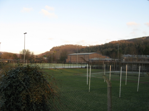
Inspirational stations No.
5,965 - Hadnock Halt.
Ok, nobody has ever ranked
stations by how inspirational they are, but Hadnock Halt, with
its foot-high ten-yard-long platform and eight-year career can
hardly rank very high. By the early 1950s it was an accepted
idea that if slow branch trains were losing money the best way
to rectify this was to provide minor wayside halts in the middle
of nowhere, name them after places that may or may not exist
(or perhaps after passing roads or pubs) and make the services
slower. The provision of Hadnock Halt in 1951 was part of this
general idea. Its construction cannot have cost very much, given
that the platform barely reached rail level. It provided rail
services to a few local houses near the top end of Hadnock Lane,
about a mile out of Monmouth.
Closure in 1959 killed this
section of line altogether and soon the stop was dismantled,
with the little shelter being folded back up into its flatpack
and the nameboard taken away. By the early 2000s no trace of
Hadnock Halt remained; it was merely a large lump of earth, covered
in brambles and populated with a few sheep waiting for a train
that would never come. The Peregrine Path was run through here
by Sustrans in 2007, linking a car park on the railway trackbed
a few hundred yards to the south with Symonds Yat. The path is
an excellent memorial to Monmouth's railways. Its terminus is
in a slightly pointless location which requires people to go
a long way out of Monmouth to pick it up. However, most of them
now do it by car and the halt platform - now too low to meet
current Health and Safety standards - continues to await its
next service.
Arguably the path has, however,
raised the "inspirational" rating of Hadnock Halt by
a few hundred places. As one of only six stations on the Monmouth
network to clearly retain its platform (the others being Usk,
Raglan, St Briavels, Tintern and Tidenham) it is an excellent
example of how a little investment can last for a very long time.
In this case it has lasted nearly 60 years - five-sixths of that
time has been spent without any trains. |
|
Symonds Yat
|
Symonds Yat station was very
tidily situated. Trains from Monmouth came up the valley and
ran into the two-platform station built on the banks of the Wye,
with the building on the Up platform being cantilevered out over
the river (below the fence to the left) overlooking some rapids
with a little island in the middle. The Down platform had an
attractive timber building in the style of other station buildings
along the line - a short low structure running into a square
block with its roof set at right angles to the main building.
At the east end of the station the two tracks merged and headed
to the right of the large white building in the centre distance
(which wasn't there in those days) into Symonds Yat Tunnel, from
which they emerged into complete solitude, still on the banks
of the Wye, under the mass of Symonds Yat Rock some 400 yards
later. A picture of the station can be seen at an external link
here.
The station remained much
the same for most of its career; a quiet little place, disrupted
only by the four passenger and one goods trains which passed
through in each direction each day (Sundays excepted). In 1951
the points at the Ross end of the passing loop were removed and
the Up line truncated to form a siding, which for the rest of
the 1950s was used for a Camping Coach (essentially the rail-based
equivalent of a caravan). The complete closure of this stretch
of the line in 1959 meant that the station was simply left to
rot away, with grass growing up on the running lines. By the
time the demolition gangs arrived in 1962, after a three-year
stay of execution to allow for possible re-opening, it must have
seemed like the place was being put out of its misery. The gap
between the platforms was filled in, although the general hump
of the platforms survives.
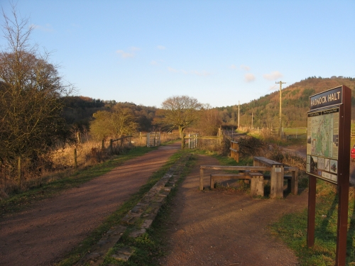
All visitors to Symonds Yat
now come by road. The station is unfortunately isolated on a
stretch of line with industrial estates at each end, making re-opening
difficult, otherwise it would seem to be somewhat ridiculous
that the site can find no better use than a car park.. The west
portal of the tunnel has been buried, but the struts for the
Up platform shelter remain - as do some of the platform slabs
at the other end of the station. |
|
Lydbrook Junction
|
Lydbrook Junction was the
point where the Forest of Dean and Monmouth rail networks met,
providing a link that - had either network met the promises made
by their promoters - should have been very successful. The Ross
and Monmouth opened through here in 1873, running out of its
tunnel through the distant hillside, crossing the Wye, passing
through the gap in the trees to the left of the brick building
and running down the track in the foreground towards Monmouth.
A passing loop was provided here with two platforms, the station
being located in the gap in the trees.
1875 brought the Severn and
Wye Railway to the site and the station became a junction. The
Severn and Wye line featured a tunnel at Mierystock (or Meirystock,
or maybe it was Mirystock, or perhaps Mery Stock), stations at
Upper and Lower Lydbrook and a fine girder viaduct over the mouth
of the Lydbrook valley. It emerged at the bottom of a typically
Severn and Wye steep gradient between the bank of trees and the
shadow in the centre of the picture. Passenger services were
run to the Severn and Wye's two platforms between 1875 and 1929,
although there is no record that they ever ran off the insular
Forest network and provided through trains to Monmouth (which
would have been jolly handy).
Two railways proposed to give
Lydbrook Junction a third railway. The first scheme was from
the South Wales and Forest of Dean Junction Railway, which would
have run from Abergavenny through Skenfrith to here, with a branch
to Ross-on-Wye. The second came from the Golden Valley Railway,
which ran trains slowly and unprofitably between Pontrilas and
Hay-on-Wye, with a scheme for a branch to here from its new line
between Pontrilas and Monmouth. Both would have been twisting
single-track railways which would have crossed the Wye and this
railway just east of Symonds Yat before curving the hillside
just above the Ross and Monmouth, running along the bramble patch
on the right and making a junction with the Severn and Wye Railway.
The aim was to extract the allegedly remunerative Forest coal
traffic. Neither line was built.
An Edison and Swann wireworks
grew up in the triangle between the lines and provided profitable
traffic. It could not save the Severn and Wye line, which fell
out of use in 1956, but it gazed benevolently over the station
as it became the only passing loop between Ross and Monmouth
in 1951. From 1959 it was the sole source of traffic for the
surviving stub of the line to Ross, but this traffic ceased in
1965 when it was taken over by a paper manufacturer. It became
the Reeds Corrugated Cases factory and an aerial view, giving
a better idea of the junction, can be seen at an external link
here.
Closure of the splendid site came in 2003. It appears to be in
excellent condition today; had the railways in the area survived
for other traffic it would perhaps still be using rail for its
output. |
|
Lydbrook Viaduct
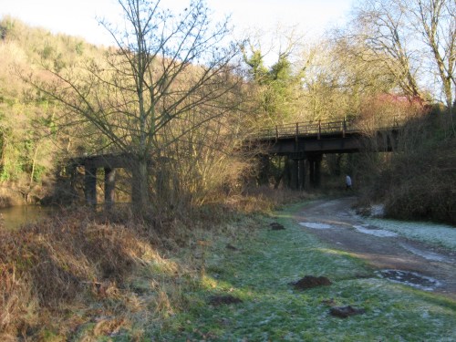
|
Lydbrook Viaduct separated
Lydbrook Junction from Lydbrook Tunnel. To the north of the tunnel
the line ran briefly along the hillside and then crossed the
river on a slightly longer and now demolished viaduct which carried
it into Kerne Bridge station. Both viaducts were laid out in
the same way - the line ran out from the abutment to the riverbank
on small approach girders supported by some rather flimsy struts
before crossing over the Wye on larger girders with bigger support
pillars. Once back on the riverbank the approach girders resume
to carry the line to the other abutment. The rails were laid
on longitudinal baulk timbers (very thick sleepers laid under
the rails with occasional timbers keeping them apart so that
the rails keep their distance) with flimsy side fences. The design
is vaguely reminiscent of that later used on the Wye Valley line
at Penallt and Tintern, although those two structures benefitted
from a spot of refinement; in this author's view Penallt Viaduct
looks more attractive and less like a mixed bag of Meccano. Unlike
Penallt, Lydbrook does not possess a footpath slung along the
side of the bridge; instead, the public footpath over the river
here (which evidently post-dates the line) runs over the main
structure.
The viaduct spent a period
in 2006 closed off for essential engineering works. Passing over
it now one feels that more essential engineering works may be
needed sooner or later, but local authorities round here have
little money. The tunnel to the north was also closed off after
closure with a solid breeze-block wall in each portal, which
seems to have proved a little inconvenient (both for maintenance
and for those who wish to explore it) since both portals now
have identically-shaped holes in their walls. The northern portal
is dry and as inviting as a dark hole ever can be, but the southern
portal is three inches deep in water which continues for some
distance into the bore. |
|
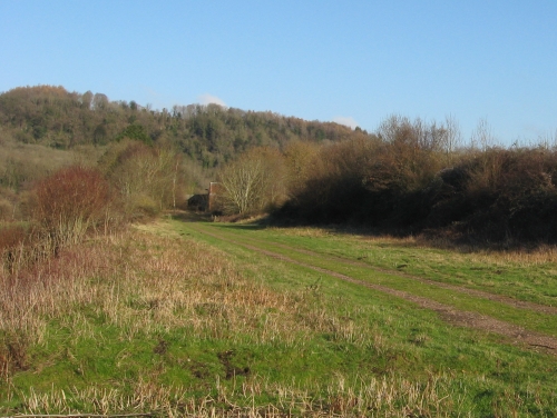
Kerne Bridge

|
Kerne Bridge was the most
northerly of the three intermediate stations opened with the
line and is now the most intact of all the stations formerly
served by Ross and Monmouth trains. The handsome little building
overlooked fields leading down to the river on this side, while
two platforms were situated between it and the road. The bridge
itself crosses the Wye at this point, linking the local civilisation
to the Bicknors and Goodrich Castle, and had to be rebuilt slightly
to fit the line under the east end of it. The Castle was the
line's pet ruin and the GWR keenly encouraged visitors.
In 1908 the Down platform
at Kerne Bridge was taken out of use and converted into a siding
by removing the pointwork at the northern end of the site. The
1930s saw this siding used for stabling a Camping Coach - a remarkably
civilised one which opened onto a platform (access to most Camping
Coaches required a certain degree of agility, since they were
normally parked on a spare siding in the goods yard with a ladder
provided for access). The Second World War stopped such frivolous
things as holidays, but a new Camping Coach was brought in for
the 1950s, giving the line two such vehicles.
Following closure, the station's
growing dereliction was made increasingly apparent by the decision
to relay the track through the Up platform with nice new concrete
sleepers and fresh ballast, contrasting with the lifted track
through the Down platform and the grass-covered platform surfaces.
After all the track was lifted it became an outdoor activities
place, with sleeping capacity being augmented by an old railway
coach (a Mk 1 BSO for those who know the jargon). Suitably enlarged,
the building is now a house (the fate of the BSO is unknown,
but it's not here any more). The platforms are long gone, since
the roads which once overlooked the station have been improved
and widened, obliterating much of the site. A small car park
sits on the goods yard, with a short footpath down to the former
viaduct towards Lydbrook. |
|
Walford Halt

|
Walford Halt was the first
of the two halts on the line to open. The timber platform with
its familiar Great Western pagoda shelter (well - moderately
familiar - the large corrogated iron shelter with open front
door and roof like a Japanese pagoda erected at Walford was the
only one on the Monmouth rail network, although the design was
common elsewhere) opened in 1931 to serve a small village. The
line had run from Kerne Bridge on a long embankment, initially
by the riverbank and then across fields. Once through the halt
trains crossed a minor road on a girder bridge just over three
miles from their destination. Most of the remainder of the journey
would be made running through farmland.
The halt was not unsuccessful
- it attracted business and provided an additional stop on a
long stationless stretch which did actually run through an area
where people lived (unlike the rest of the line). However, its
location on a generally unremunerative line meant that its future
was poor and it closed after slightly less than 28 years of use.
Both platform and shelter have vanished, although the steps up
to the former halt survive today. The overbridge to the north
of the stop has also gone; the southern abutment survives, but
the northern one has been torn away to provide a farmer with
access from the road onto a farm track running along the trackbed.
Part of the embankment behind the northern abutment survives
and is now held back by a retaining wall, which proclaims that
the line's three-letter identifying code is "ROS" and
that it is 3 miles and 2 chains from the junction at Ross. |
|
South of Ross
|
After a couple of miles of
running through farmland the railway passed through a short cutting
and emerged here, running into the suburbs on the south side
of Ross. The terminus was still about a mile away as the line
passed between housing estates and under a couple of roads in
an area of Ross known as Tudorville. It then ran around the eastern
flank of the town, acting as a bit of a greenbelt with housing
and industry to the west and fields rising up to the trees of
the Forest of Dean to the east.
This area of suburbs seems
to have mostly grown up while the railway was still alive, providing
a huge area of business on the outskirts of the town which was
some distance from the railway station. Despite the enthusiasm
of British Rail and the GWR for providing halts where nobody
lived, however, no stopping places were ever provided on this
last mile of track as it ran through built up areas and leafy
suburbia. One feels that a Ross South Halt would have attracted
far more traffic than Hadnock Halt. Nonetheless, trains simply
ran through the south-east end of Ross without stopping and the
locals either bought cars or caught the bus.
Nowadays a cycle route runs
around the east flank of Ross along the trackbed. It has users
but often seems a little tired. Of particular interest is that
every single railway bridge around Ross has either been infilled
or removed and, despite the Ross and Monmouth Railway not featuring
a single level crossing on its entire route, users of this path
must cross the three intermediate roads on the level. |
|
Ross-on-Wye
|
Ross on Wye station was opened
as the sole intermediate passing loop on the Hereford, Ross and
Gloucester Railway. The railway entered Ross from the north-west
after a run from Hereford which barely went a yard without some
impressive engineering feature - whether it be a long tunnel,
a sizeable river crossing, a high embankment or a remarkably
deep cutting. The run through Ross featured a rather impressive
and now largely long-gone viaduct through the town centre before
the line arrived at the fine brick station on the outskirts of
the town. The line then departed across country and managed a
fairly unimpressive bit of line for the rest of the journey to
the junction with the mainline at Grange Court, with the exception
of a tunnel at Lea (a village which is now home of narrow-gauge
loco workshops Alan Keef Ltd.) and a couple more fine cuttings
and embankments. Initially built to the 7'¼" broad
gauge, the line was only the second such line in the country
to be converted to standard gauge (4'8½") when the
construction teams descended on the route for a weekend in 1869.
The Ross and Monmouth Railway
approached Ross station on an embankment, slipping into a shallow
cutting which eventually opened out and allowed the line to arrive
in its little bay platform to one side of the station at about
ground level. Branch locomotives could live at Ross, which had
its own engine shed and - for many years - its own turntable.
The Hereford, Ross and Gloucester
Railway was killed in May 1964, bringing down the curtain on
Ross's rail services. After making the usual objections the local
authority took over the site and decided that while it wholly
opposed the closure of the line it saw no reason to provide for
its reopening. The station buildings were demolished - although
the goods shed and engine shed survive - and the site redeveloped.
The picture looks west from the approximate site of the east
end of the Gloucester-bound platform.
A building not dissimilar
to that once at Ross was built at Kidderminster station in the
late 1980s for the Severn Valley Railway's heritage steam trains
from Bridgnorth. However, the prospects of seeing such a station
building at Ross again are remote. |
This website likes to consider
the possibilities of reopening lines as (probably unsuccessful)
attempts at commercial enterprise connected with the national
rail network, but with both ends blocked by industrial estates
and many miles of abandoned trackbed separating said ends from
the wider network anyway such an outcome is highly unlikely for
the Ross and Monmouth route. Nonetheless, the line's wonderful
scenery makes it an excellent candidate for re-opening as a tourist
link. Steam-hauled services between Ross and Monmouth would have
to terminate on the outskirts of both towns but could still provide
a link that would bring people to Symonds Yat and Goodrich Castle
without the need for a car. Such a service would be unable to
compete with the motor car for daily traffic but it is impossible
to produce a rail link along this trackbed which could compete
with the 15 minute drive between Ross and Monmouth along the
modern road anyway. Perhaps a slower, more thoughtful connection
would be preferable here. In due course passengers could be brought
in to the south end by rail from Chepstow, but unfortunately
a return of services between Hereford, Ross and Gloucester is
dependent on the demise of the Ross-on-Wye industrial estate.
Consequently it is hard to
see the return of the old 1950s network radiating out of Ross
as very likely at the moment. Instead one is tempted to feel
that extending the current Peregrine Path from Symonds Yat through
Lydbrook to meet up with the Forest of Dean cycle network would
be a more productive use of the trackbed. If a steam railway
group began work at the Ross end it would be some years before
they wanted the trackbed south of Lydbrook Junction anyway. Meanwhile
cyclists on the Peregrine Path could be allowed to arrive at
the route using sustainable transport by reopening the route
from Chepstow to Monmouth, which is a little more intact and
can be more readily linked into the national rail network. The
old factory at Lydbrook would make a rather nice tourist hotel
with no shortage of car parking.
|
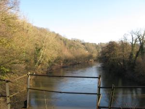
Background Picture: The splendour of the Ross and Monmouth
scenery is such that it can even be appreciated in the depths
of winter. This is the view looking east from Lydbrook Viaduct,
up the Wye Valley towards Lydbrook itself. The junction station
is to the south while the line plunges into a lengthy tunnel
a little to the north, making this a short glimpse of the view
between the two. |
Middleton Press have divided
the line into two; Monmouth to Lydbrook can be found under Branch Lines to Monmouth and Lydbrook
to Ross is under Branch Lines around Ross. Both
are by Vic Mitchell and Keith Smith and were published in 2008.
The Ross, Monmouth and Pontypool Road Line by Stanley
C. Jenkins is the Oakwood Press offering (originally published
2002 (blue cover), new edition 2009 (yellow cover)). The National
Archives at Kew hold the GWR plans of the line under Rail
274/78.
<<<Wye
Valley Railway<<<
>>>Coleford,
Monmouth, Usk and Pontypool Railway>>>
>>>Monnow
Valley Railway>>>
<<<Railways
Department<<< |